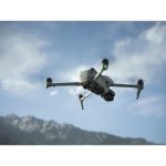
| Aircraft |
|
| Takeoff Weight |
724 g |
| Dimensions |
Folded (without propellers): 214.19×100.63×89.17 mm (L×W×H)
Unfolded (without propellers): 266.11×325.47×106.00 mm (L×W×H) |
| Max Ascent Speed |
10 m/s |
| Max Descent Speed |
10 m/s |
| Max Horizontal Speed |
At sea level, in windless conditions:
21 m/sAt sea level, with 6 m/s tailwind, while flying in the same direction as the wind:
27 m/s* Measured in a wind tunnel test environment when taking off from an altitude of 0 meter and ascending vertically to a height of 1.5 meters above the ground in the Sport mode, and is for reference only. Always pay attention to reminders on the camera view during your flight.
* 19 m/s in the EU region. |
| Max Takeoff Altitude |
6000 m |
| Max Flight Time |
45 minutes
Measured by DJI Air 3S flying forward at a constant speed of 32.4 kph in a windless environment at sea level, with Obstacle Avoidance Action set to Brake, in photo mode, and from 100% battery level until 0%. Data is for reference only. Always pay attention to reminders in the app during your flight. |
| Max Hovering Time |
41 minutes
Measured by DJI Air 3S hovering in a windless environment at sea level, with Obstacle Avoidance Action set to Brake, in photo mode, and from 100% battery level until 0%. Data is for reference only. Always pay attention to reminders in the app during your flight. |
| Max Flight Distance |
32 km
Measured by DJI Air 3S flying forward at a constant speed of 48.6 kph in a windless environment at sea level, with Obstacle Avoidance Action set to Brake, in photo mode, and from 100% battery level until 0%. Data is for reference only. Always pay attention to reminders in the app during your flight. |
| Max Wind Speed Resistance |
12 m/s |
| Max Pitch Angle |
36° |
| Operating Temperature |
-10° to 40° C (14° to 104° F) |
| Global Navigation Satellite System |
GPS + Galileo + BeiDou |
| Hovering Accuracy Range |
Vertical:
±0.1 m (with vision positioning)
±0.5 m (with satellite positioning)Horizontal:
±0.3 m (with vision positioning)
±0.5 m (with satellite positioning) |
| Internal Storage |
42 GB |
| Class |
C1 (EU) |
| Camera |
|
| Image Sensor |
Wide-Angle Camera: 1-inch CMOS, 50MP Effective Pixels
Medium Tele Camera: 1/1.3-inch CMOS, 48MP Effective Pixels |
| Lens |
Wide-Angle Camera
FOV: 84°
Format Equivalent: 24 mm
Aperture: f/1.8
Focus: 0.5 m to ∞Medium Tele Camera
FOV: 35°
Format Equivalent: 70 mm
Aperture: f/2.8
Focus: 3 m to ∞ |
| ISO Range |
Video
Normal:
100-12800 (Normal)
100-3200 (D-Log M)
100-3200 (HLG)
Slow Motion:
100-6400 (Normal)
100-3200 (D-Log M)
100-3200 (HLG)Photo
100-6400 (12 MP)
100-3200 (48 MP and 50 MP) |
| Shutter Speed |
Wide-Angle Camera
12MP Photo: 1/8000-2 s (2.5-8 s for simulated long exposure)
50MP Photo: 1/8000-2 sMedium Tele Camera
12MP Photo: 1/16000-2 s (2.5-8 s for simulated long exposure)
48MP Photo: 1/16000-2 s |
| Max Image Size |
Wide-Angle Camera: 8192×6144
Medium Tele Camera: 8064×6048 |
| Still Photography Modes |
Wide-Angle Camera
Single Shot: 12 MP and 50 MP
Burst Shooting: 12 MP, 3/5/7 frames; 50 MP, 3/5 frames
Automatic Exposure Bracketing (AEB): 12 MP, 3/5/7 frames; 50 MP, 3/5 frames at 0.7 EV step
Timed: 12 MP, 2/3/5/7/10/15/20/30/60 s; 50 MP, 5/7/10/15/20/30/60 sMedium Tele Camera
Single Shot: 12 MP and 48 MP
Burst Shooting: 12 MP, 3/5/7 frames; 48 MP, 3/5 frames
Automatic Exposure Bracketing (AEB): 12 MP, 3/5/7 frames; 48 MP, 3/5 frames at 0.7 EV step
Timed: 12 MP, 2/3/5/7/10/15/20/30/60 s; 48 MP, 5/7/10/15/20/30/60 s |
| Photo Format |
JPEG/DNG (RAW) |
| Video Resolution |
Wide-Angle Camera/Medium Tele Camera:
H.264/H.265
4K: 3840×2160@24/25/30/48/50/60/120*fps
FHD: 1920×1080@24/25/30/48/50/60/120*/240*fps
2.7K Vertical Shooting: 1512×2688@24/25/30/48/50/60fps* Recording frame rates. The corresponding video plays as a slow-motion video. Slow-motion videos and 4K video recordings only support H.265 encoding. |
| Video Format |
MP4 (MPEG-4 AVC/H.264, HEVC/H.265) |
| Max Video Bitrate |
H.264/H.265: 130 Mbps |
| Supported File System |
exFAT |
| Color Mode and Sampling Method |
Wide-Angle/Medium Tele Camera
Normal (FHD/2.7K): 8-bit 4:2:0 (H.264)
Normal (FHD/2.7K): 10-bit 4:2:0 (H.265)
HLG/D-Log M (FHD/2.7K): 10-bit 4:2:0 (H.264/H.265)
Normal/HLG/D-Log M (4K): 10-bit 4:2:0 (H.265) |
| Digital Zoom |
Wide-Angle Camera: 1-2.9x
Medium Tele Camera: 3-9x |
| Gimbal |
|
| Stabilization |
3-axis mechanical gimbal (tilt, roll, pan) |
| Mechanical Range |
Tilt: -135° to 70°
Roll: -50° to 50°
Pan: -27° to 27° |
| Controllable Range |
Tilt: -90° to 60°
Pan: -5° to 5° |
| Max Control Speed (tilt) |
100°/s |
| Angular Vibration Range |
±0.0037° |
| Sensing |
|
| Sensing Type |
Omnidirectional binocular vision system, supplemented with forward-facing LiDAR and an infrared sensor at the bottom of the aircraft |
| Forward |
Measurement Range: 0.5-18 m
Detection Range: 0.5-200 m
Effective Sensing Speed: Flight Speed ≤ 15 m/s
FOV: Horizontal 90°, Vertical 72° |
| Backward |
Measurement Range: 0.5-18 m
Effective Sensing Speed: Flight Speed ≤ 14 m/s
FOV: Horizontal 90°, Vertical 72° |
| Lateral |
Measurement Range: 0.5-30 m
Effective Sensing Speed: Flight Speed ≤ 14 m/s
FOV: Horizontal 90°, Vertical 72° |
| Upward |
Measurement Range: 0.5-18 m
Effective Sensing Speed: Flight Speed ≤ 6 m/s
FOV: Front and Back 72°, Left and Right 90° |
| Downward |
Measurement Range: 0.3-14 m
Effective Sensing Speed: Flight Speed ≤ 6 m/s
FOV: Front and Back 106°, Left and Right 90° |
| Operating Environment |
Forward, Backward, Left, Right, and Upward:
Surfaces with discernible patterns and adequate lighting (lux > 1)
Downward:
Surfaces with discernible patterns, diffuse reflectivity > 20% (e.g., walls, trees, people), and adequate lighting (lux > 1) |
| 3D Infrared Sensor |
Forward-Facing LiDAR
Measurement Range (nighttime): 0.5-25 m (reflectivity > 10%)
FOV: Up and Down 60°, Left and Right 60°Downward-Facing Infrared Sensor
Measurement Range: 0.3-8 m (reflectivity > 10%)
FOV: Front and Back 60°, Left and Right 60° |
| Video Transmission |
|
| Video Transmission System |
O4 |
| Live View Quality |
Remote Controller:
1080p/30fps, 1080p/60fps |
| Operating Frequency |
2.4000-2.4835 GHz
5.170-5.250 GHz
5.725-5.850 GHz
Operating frequency allowed varies among countries and regions. Refer to local laws and regulations for more information. |
| Transmitter Power (EIRP) |
2.4 GHz:
< 33 dBm (FCC)
< 20 dBm (CE/SRRC/MIC)5.1 GHz:
< 23 dBm (CE)5.8 GHz:
< 33 dBm (FCC)
< 30 dBm (SRRC)
< 14 dBm (CE) |
| Max Transmission Distance (unobstructed, free of interference) |
FCC: 20 km
CE: 10 km
SRRC: 10 km
MIC: 10 kmMeasured in an unobstructed outdoor environment free of interference. The above data shows the farthest communication range for one-way, non-return flights under each standard. Always pay attention to RTH reminders in the app during your flight. |
| Max Transmission Distance (unobstructed, with interference) |
Strong Interference: Urban landscape, approx. 1.5-4 km
Medium Interference: Suburban landscape, approx. 4-10 km
Low Interference: Suburb/Seaside, approx. 10-20 kmMeasured under FCC standard in unobstructed environments with typical interference. Used for reference purposes only and provides no guarantee for actual transmission distance. |
| Max Transmission Distance (obstructed, with interference) |
Low Interference and Obstructed by Buildings: Approx. 0-0.5 km
Low Interference and Obstructed by Trees: Approx. 0.5-3 kmMeasured under FCC standard in obstructed environments with typical low interference. Used for reference purposes only and provides no guarantee for actual transmission distance. |
| Max Download Speed |
O4:
10 MB/s (with DJI RC-N3)
10 MB/s (with DJI RC 2)
Wi-Fi 5: 30 MB/s** Measured in a laboratory environment with little interference in countries/regions that support both 2.4 GHz and 5.8 GHz. Download speeds may vary depending on the actual conditions. |
| Lowest Latency |
Aircraft + Remote Controller: Approx. 120 ms
Depending on the actual environment and mobile device. |
| Antenna |
6 antennas, 2T4R |
| Wi-Fi |
|
| Protocol |
802.11 a/b/g/n/ac |
| Operating Frequency |
2.400-2.4835 GHz
5.725-5.850 GHz |
| Transmitter Power (EIRP) |
2.4 GHz:
< 20 dBm (FCC/CE/SRRC/MIC)5.8 GHz:
< 20 dBm (FCC/SRRC)
< 14 dBm (CE) |
| Bluetooth |
|
| Protocol |
Bluetooth 5.2 |
| Operating Frequency |
2.400-2.4835 GHz |
| Transmitter Power (EIRP) |
< 10 dBm |
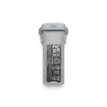
| Battery |
|
| Capacity |
4276 mAh |
| Weight |
Approx. 247 g |
| Nominal Voltage |
14.6 V |
| Max Charging Voltage |
17.2 V |
| Type |
Li-ion 4S |
| Energy |
62.5 Wh |
| Charging Temperature |
5° to 40° C (41° to 104° F) |
| Charging Time |
Approx. 80 minutes (with DJI 65W Portable Charger)
Approx. 60 minutes (with DJI 100W USB-C Power Adapter and Battery Charging Hub) |
| Charger |
|
| Input |
DJI 65W Portable Charger:
100-240 V (AC), 50-60 Hz, 2 ADJI 100W USB-C Power Adapter:
100-240 V (AC), 50-60 Hz, 2.5 A |
| Output |
DJI 65W Portable Charger:
USB-C
5 V, 5 A
9 V, 5 A
12 V, 5 A
15 V, 4.3 A
20 V, 3.25 A
5-20 V, 3.25 AUSB-A
5 V, 2 ADJI 100W USB-C Power Adapter:
Max 100 W (total)When both ports are used, the max output power of one port is 82 W, and the charger will dynamically allocate the output power of the two ports according to the power load. |
| Rated Power |
DJI 65W Portable Charger: 65 W
DJI 100W USB-C Power Adapter: 100 W |
| Battery Charging Hub |
|
| Input |
USB-C: 5-20 V, max 5 A |
| Output (power accumulation) |
Battery Port: 12-17.2 V, 3.5 A |
| Output (charging) |
Battery Port: 12-17.2 V, max 5 A |
| Output (USB) |
USB-C:
5 V, 3 A
9 V, 5 A
12 V, 5 A
15 V, 5 A
20 V, 4.1 A |
| Charging Type |
Three batteries charged in sequence |
| Compatibility |
DJI Air 3 Intelligent Flight Battery
DJI Air 3S Intelligent Flight Battery |
| Storage |
|
| Recommended microSD Cards |
Lexar 1066x 64GB V30 U3 A2 microSDXC
Lexar 1066x 128GB V30 U3 A2 microSDXC
Lexar 1066x 256GB V30 U3 A2 microSDXC
Lexar 1066x 512GB V30 U3 A2 microSDXC
Kingston Canvas GO! Plus 64GB V30 U3 A2 microSDXC
Kingston Canvas GO! Plus 128GB V30 U3 A2 microSDXC
Kingston Canvas GO! Plus 256GB V30 U3 A2 microSDXC
Kingston Canvas GO! Plus 512GB V30 U3 A2 microSDXC |


 Παραλαβή από το κατάστημα
 Αποστολή με Courier
_battery-detached.jpg "DJI Air 3S Fly More Combo(DJI RC 2)_battery detached")


_from-above_battery-detached.jpg "DJI Air 3S Fly More Combo(DJI RC 2)_from above_battery detached")

_battery-detached-150x150.jpg)

_from-above_battery-detached-150x150.jpg)